Ecocultural Design Working Group
Before initiating the Ecocultural Design Working Group, a community meeting was held to review existing materials and set objectives for the creation of a minimal viable prototype on the timeline of Phase II.
All project participants convened to orient to the overarching goals of Phase II, forming teams based on specific objectives identified during the community meeting. The Ecocultural Design Working Group was formed to see through the design and technical implementation of the ecocultural mapping prototype.
Design priorities
The Ecocultural Design Working Group began by identifying key dimensions of the mapping framework to be developed, thematized around essential mapping classifications and features of the landscape that had been identified as holding cultural and ecological values (Figure 1). Interactive design elements were proposed, considered and prioritized based on the following criteria:
- bringing forward and respectfully representing Indigenous cultural content
- optimizing inclusive and intuitive interactions with the GUI
- ensuring the fidelity of both ecological and cultural content
We prioritized design elements and functions that we identified as being key to achieving a minimum viable prototype in the short term, while also taking note of any desired feature requests that could not be delivered on the timeline of Phase II.
Table 12 summarizes the tasks completed by this working group.
Table 12. Phase II: Design Working Group Tasks
| Task | Start | End |
|---|---|---|
| Set objectives to create “minimal viable prototype” on timeline of Phase II | January 2022 | January 2022 |
| Identify dimensions of mapping framework (e.g., land classifications) that can be Indigenized with Hul’q’umi’num’ names and perspectives | January 2022 | March 2022 |
| Continue tabulation of ecological and cultural attributes and values based on ongoing field work and cultural mapping exercises | January 2022 | March 2022 |
| Digitize new features (marine, shoreline) based on drone-based ortho-imagery collected in 2021 | January 2022 | January 2022 |
| Thematize / simplify GIS to frame map in terms of ecological and cultural regions of interest | January 2022 | February 2022 |
| Update GIS and export to GeoJSON format for javascript-based digital map creation and data visualization | February 2022 | March 2022 |
| Design map tiles to reflect ecological communities | January 2022 | March 2022 |
| Organize alternating design and community meetings to refine vision and design of GUI with input from project participants | January 2022 | March 2022 |
| Implement design concepts into GUI | February 2022 | March 2022 |
| Weave ecological and cultural multimedia content into GUI | March 2022 | March 2022 |
Weaving content together
The Design Working Group collaborated closely with the Cultural Learning Working Group and Ecocultural Mapping Working Group to ensure any content generated by these working groups had a place reserved within the evolving ecocultural mapping framework. Parameters and data standards were set for multimedia content generated by the latter working groups (e.g., audio, video, textual, and tabulated data).
This working group also workshopped its own content, such as the design and implementation of map tiles and symbology to reflect ecological communities and cultural values of species (Figure 3).
Indigenous participants were consulted in all aspects of the ecocultural mapping framework design, including map tiles (e.g., camas bulbs to represent woodlands) and icons to represent the values of culturally important species.
Community meetings were scheduled to bring together all project participants to review progress being made at regular intervals, and input was also sought from key project stakeholders.
Finally, this working group was charged with the task of weaving together the ecological and cultural multimedia content generated by the other working groups into the online map.
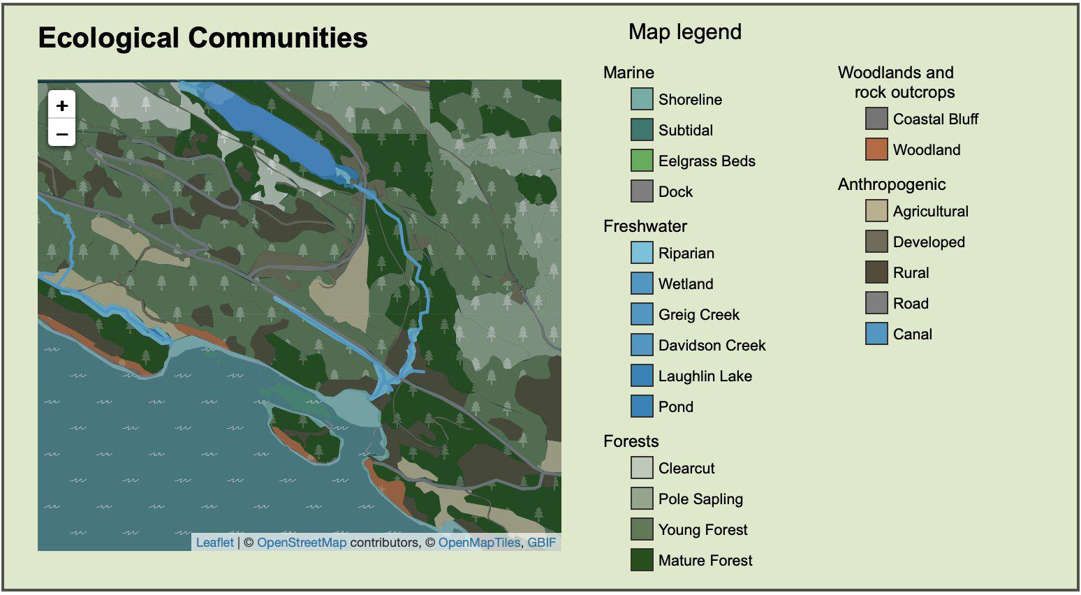
Figure 3. Map panel showing map symbology and tiles for several ecological communities represented at Xetthecum. Note the high definition contours of marine foreshore, digitized based on drone ortho-imagery. Woodlands are represented with a camas bulb icon (spánxw), to highlight this cultural keystone species, and the forests represented with ts’sey (Douglas-fir).